The provision of information on the extent, type, and dynamics of vegetated landcover is critical in a number of applications including, but not limited to, carbon monitoring, biodiversity assessment, situational awareness, and habitat suitability modelling.
Remote Sensing (RS) data, in particular those acquired from spaceborne platforms, offer the ability to provide such information. There has been much research focusing on the use of optical RS data from sensors such as Landsat. Such data are only able to provide information on the vegetation canopy, from which structure must be inferred, and its availability is limited by cloud cover. Synthetic aperture radar (SAR) instruments, in particular those operating at longer wavelengths (e.g., L-band; ~ 25 cm) are able to penetrate the canopy and provide information on vegetation structure. Data acquired from SAR sensors are also unaffected by cloud cover, making them well suited to monitoring applications, especially in areas with near continuous cloud cover such as tropical biomes.
Within MiXIL, our current research is focusing on two major biomes; wetlands, with study sites North America, and wooded savanna with study sites in Queensland, Australia. Key areas of interest are classification and change detection.
Automatic Classification
Consistently and accurately extracting information (e.g., vegetation or wetlands classes) from remote sensing data, especially over large areas, requires the development and application of automatic classification methods. Such methods must be flexible and allow the inclusion of ancillary datasets. Current research at MiXIL is investigating Classification and Regression Tree (CART) approaches such as Random Forests, as these have been shown to provide improved accuracy over traditional unsupervised (e.g., ISODATA) and supervised (e.g., maximum-likelihood) methods, especially for spatially extensive data sets.

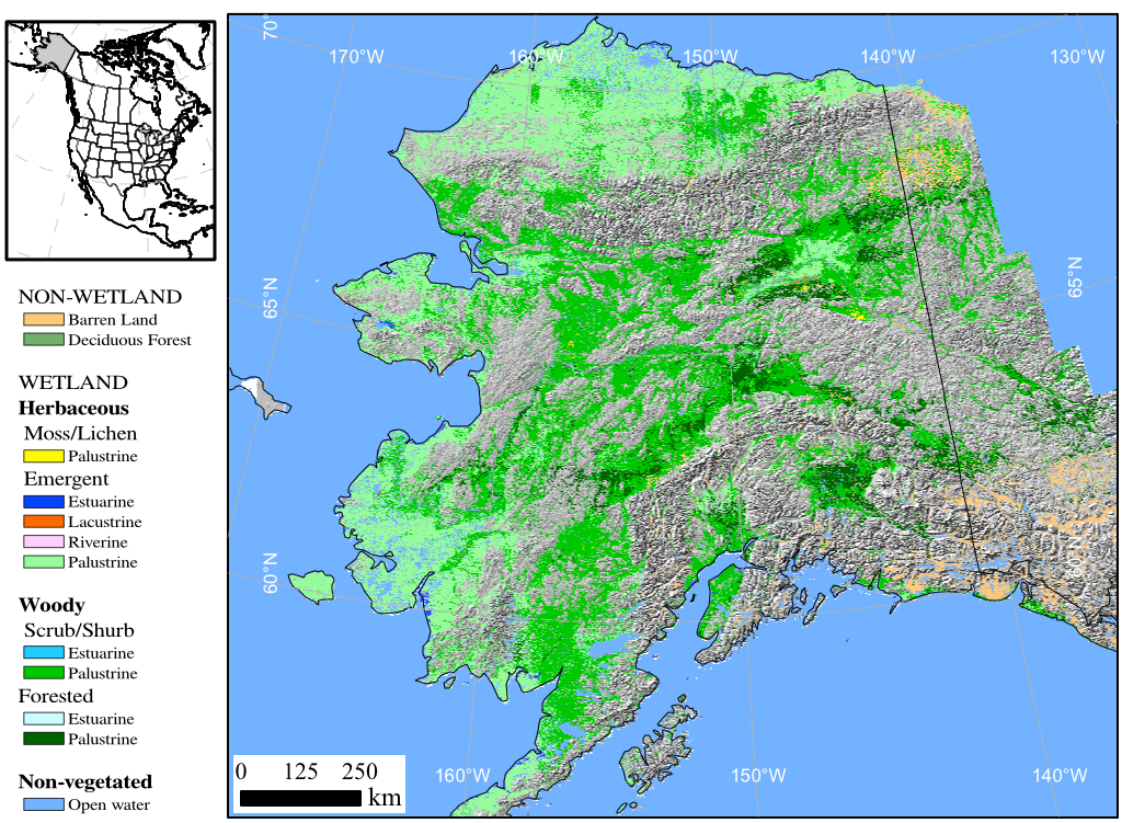
Wetlands map of Alaska generated from PALSAR L-band radar imagery and ancillary datasets at 100 m resolution (Clewley et al 2014)
Change detection
The ability to detect short- and long-term changes is important for quantifying Afforestation, Reforestation and Deforestation (ARD) activities, detecting more subtle changes such as land degradation, and effects of warming and/or drying trends on landover transitions. However, separating actual change from seasonality, weather effects, classification uncertainty, and instrument error presents a challenge when using remote sensing data from multiple dates. The problem is further complicated when considering data from multiple sensors with different characteristics. Data from different sensors are sometimes poorly aligned with one another, for example, necessitating the implementation of an accurate and efficient multi-modal registration process. Research at MiXIL is focusing on ways of quantifying uncertainties associated with change maps.
Publications
- D. Clewley, J. Whitcomb, M. Moghaddam, K. McDonald, B. Chapman and P. Bunting, “Evaluation of ALOS PALSAR data for high-resolution mapping of vegetated wetlands in alaska”, Remote Sensing, vol. 7, no. 6, pp. 7272-7297, June 2015.
- Whitcomb, J., M. Moghaddam, K. McDonald, J. Kellndorfer, and E. Podest, “Mapping wetlands of Alaska from L-band SAR imagery,” C. J. Remote Sensing, vol. 35, no. 1, pp. 54-72, February 2009. (Winner of Best Journal Paper Award for 2009)
- Clewley, D., J. Whitcomb, M. Moghaddam, and K. McDonald, Mapping the State and Dynamics of Boreal Wetlands using Synthetic Aperture Radar, in Advances in Wetlands Mapping, M. Lang and R. Tiner (Eds.), January 2014.